
The Ground Probing Radar (GPR) method has been customised by Subsurface Geotechnical for water engineering geophysical investigations. Applications include the concrete testing of barrages, weirs, locks and dams. Water-borne geophysical surveys can also profile the thickness of mobile bed in river channels and assess the extent of siltation in canals and reservoirs. The geophysical survey results are presented in an engineering compatible format readily understandable by the client.
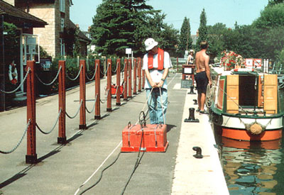
Investigating a gauging station by GPR
For water-borne surveys only the GPR transducer is actually towed over the water surface. The remaining equipment is either set-up on land, or mounted inside a boat for larger scale operations. Pulses of radio frequency energy are transmitted through the water by the transducer, propagating downwards into the river bed or underwater engineering structures like concrete aprons. At the boundary between electrically contrasting materials such as water-concrete; water-sediment or concrete-substrata the pulses are reflected back towards the surface, where they are detected by the receiver component of the transducer for digital storage by the control module.
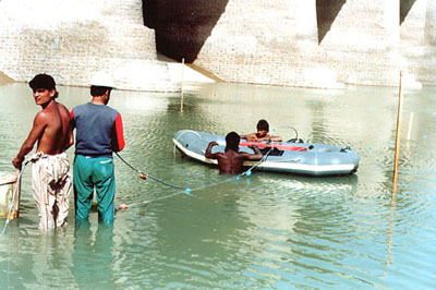
Testing a barrage apron on the River Indus
The acquired data can enhanced by processing, prior to output as a digital display or hard-copy graphic section of the reflection interfaces beneath the survey line. Expert interpretation procedures are then applied to identify critical reflection events on the radar trace. Key reflections are correlated with real boundaries associated with the water engineering structure. These can include the base of the water column; the top and bottom of a concrete apron and internal defects such as voids and honeycombing.
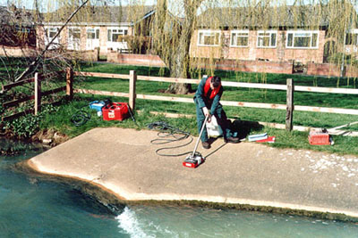
Towpath GPR survey using low frequency antenna unit
GPR surveys are particularly useful for locating voids hidden beneath a towpath or behind a lock chamber. Longitudinal profiles can be surveyed along the towpath to produce sections behind the lock wall. The internal structure of a lock wall is investigated by vertical profiles down the face of the wall. Results can be used to determine the wall profile and thickness and to locate internal defects. Water-borne profiles locate voids within or beneath a weir apron. If a heavy crane is required for remedial operations such as gate replacement, a GPR survey is carried out over the proposed track and station of the crane.
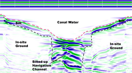
GPR can be readily applied to investigate canals for quantifying the extent of siltation. Data is acquired by towing transverse profiles across the surface of the canal. Interpretation procedures determine the profile of the original navigation channel, so that the thickness of accumulated silt can be measured. Wrecks and other obstructions buried within the silt can also be located and mapped, to provide vital information on potential hazards to dredging and other restoration operations
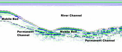
Fluvial investigations assess scour potential on the upstream side of bridge piers and weirs by measuring the thickness of the mobile bed, and by profiling the permanent river channel. The survey results allow accurate targeting of follow-up intrusive and diving investigations.
Investigations of weirs, barrages, dams, locks and canals
Detects underwater voids and defects in concrete and masonry
Profiles alluvial channels and mobile bed thickness
Maps obstructions and wrecks on river and lake bottoms
Defines scour around piers, abutments and weirs
Measures thickness of reservoir and canal siltation
Phone us at: +44-1905-619531 or e-mail us at: [email protected]