
Magnetic geophysical surveys measure small, localised variations in the Earth's magnetic field. The magnetic properties of naturally occurring materials such as magnetic ore bodies and basic igneous rocks allows them to be identified and mapped by magnetic surveys. Strong local magnetic fields or anomalies are also produced by buried steel objects. Magnetometer surveys find underground storage tanks, drums, piles and reinforced concrete foundations by detecting the magnetic anomalies they produce.
Locating mineshafts with a vertical field gradiometer
Magnetometers are highly accurate instruments that measure local magnetic fields to a high degree of precision. Magnetometer systems used for commercial applications include proton precession, caesium vapour and gradiometer magnetometers. The systems operate on broadly similar principles utilising proton rich fluids surrounded by an electric coil. A current is applied through the coil, which generates a magnetic field that temporarily polarises the protons. When the current is removed, the protons realign or precess along the line of the Earth's magnetic field. The proton precession produces a small but measurable electric current in the coil, at a frequency proportional to the magnetic field intensity.
Gradiometers measure magnetic field gradient rather than total field strength. Magnetic gradient anomalies generally give a better definition of shallow buried features such as buried tanks and drums, but are less useful for geological tasks. The depth penetration of magnetic surveys is unaffected by high electrical ground conductivities, which makes them useful on sites with saline groundwater, clay or high levels of contamination where the GPR and Electromagnetic methods struggle.
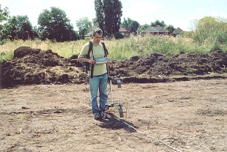
Data acquisition for magnetic surveys involves taking a series of point readings at regular intervals on a survey grid. The spacing between grid lines and reading stations is dependent upon the application. Generally smaller targets require higher resolution surveys and denser survey grids. Modern caesium vapour magnetometers and gradiometers are more sophisticated, allowing data to be collected either in continuous mode or as a set of point readings.
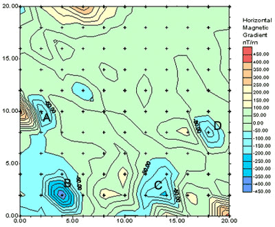
Data is stored digitally on site, and later downloaded on to a PC for post-survey processing and interpretation. Various interpretation techniques are applied to the data using specialist interactive software to identify the targeted anomalies. A combination of contouring and colour shading is used to highlight anomaly patterns. Survey results are presented as plans tied in to site co-ordinates, in an engineering compatible format readily understandable by the client.
Finding buried steel tanks and waste drums
Detecting iron and steel obstructions
Locating unmarked mineshafts
Accurately mapping archaeological features>
Mapping basic igneous intrusives & faults
Evaluating the size and shape of ore bodies